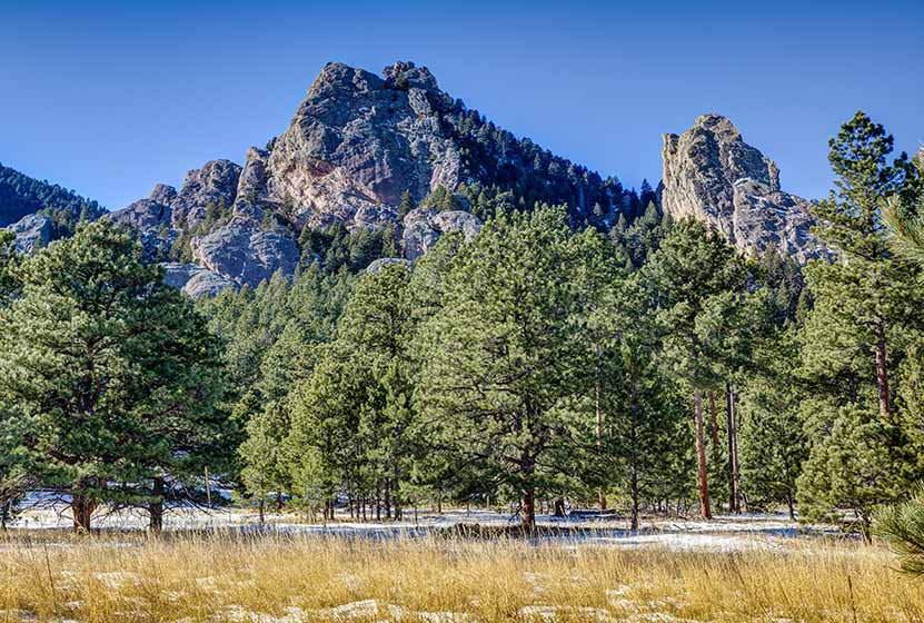
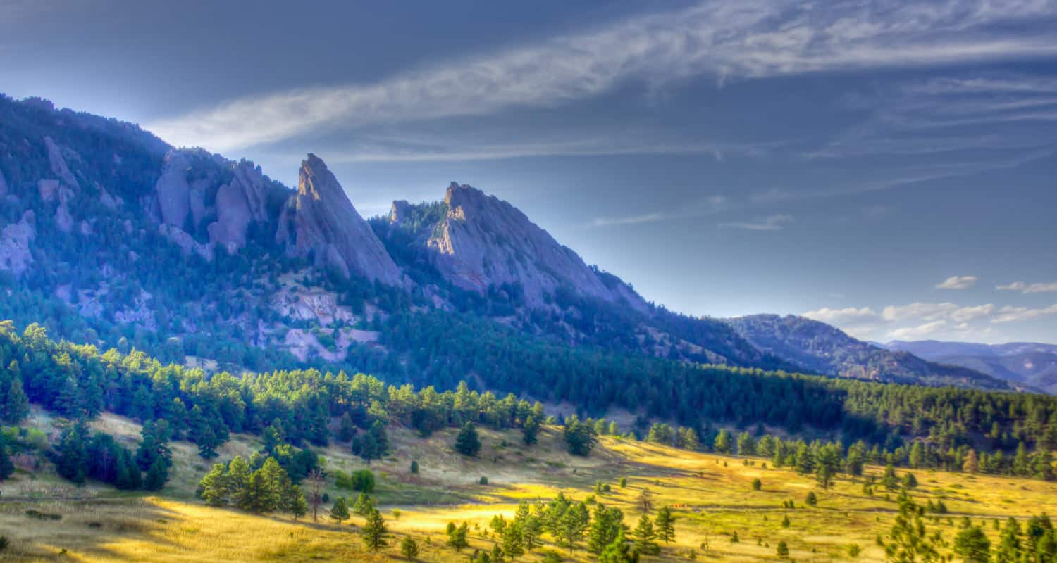
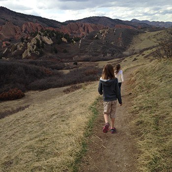
Shanahan Ridge Hike Near Boulder
The Shanahan Ridge Loop Hike is an easy, 4-mile lollipop-loop trail with stunning views of the Shanahan Ridge of the Flatirons in Boulder, Colorado. Explore the full Shanahan Ridge Loop hike profile below for trail map, driving directions, and more tips and details to help you enjoy this hike in Boulder.
Trail Snapshot: Shanahan Ridge Loop Trail in Boulder, Colorado
| Hike Distance | 4 Miles |
|---|---|
| Difficulty | Easy |
| Duration | Approx 2 hrs |
| Trail Type | Lollipop-Loop |
| Starting Elevation | Approx. 5500′ |
| Elevation Gain | Approx +900′ |
| Seasons | Year Round |
| Dogs | Allowed On Leash |
| Hike Trail Map | Click for a Map of Shanahan Ridge Trail |
| Denver Drive Time | 40 Min |
| Driving Directions to Shanahan Ridge Trailhead | Click for Google Map |
| Town Nearest Hike | Boulder, Colorado |
| Beauty | meadows, wildflowers, peak views, pine forest |
| Activities | Hiking, Photography, Trail Running |
Parking & Trailhead Information for Shanahan Ridge Loop Trail
The Shanahan Ridge Trailhead is located just along Lehigh Street south of Boulder. From US 36, follow Table Mesa Drive West to its intersection with CO 93. Turn left onto 93 and follow it for less than a mile. Turn right onto Greenbriar Boulevard which eventually becomes Lehigh Street. The trailhead is on the left/southwest side of the road and marked by a trail post and trash receptacle. There is actually no parking lot because the trailhead is located in a residential area. Because of this please exercise extra care and respect for the residents as you park along Lehigh or adjacent streets. Be aware of city parking signage.
The Hike: Shanahan Ridge Loop Trail
The Shanahan Ridge loop is best hiked clockwise in order to gain the best views of the Flatirons and surrounding countryside. Going left on the first junction will take you onto a connector trail that will next intersect with the South Fork Shanahan Trail. This trail begins with a gradual ascent which becomes more demanding. If you are acclimatized to the altitude and hike a fair amount, you'll find this segment easy; but beginner hikers and those of us who are not in the best of shape will find this a moderately demanding trail.
Continue on the South Fork Shanahan Trail for about 1.8 miles as it weaves through ponderosa forest and opens out to captivating vistas of the Flatirons. The trail will terminate at a junction with the Mesa Trail. Follow this trail North (right) as it winds along the base of the Shanahan Ridge of the Flatirons.
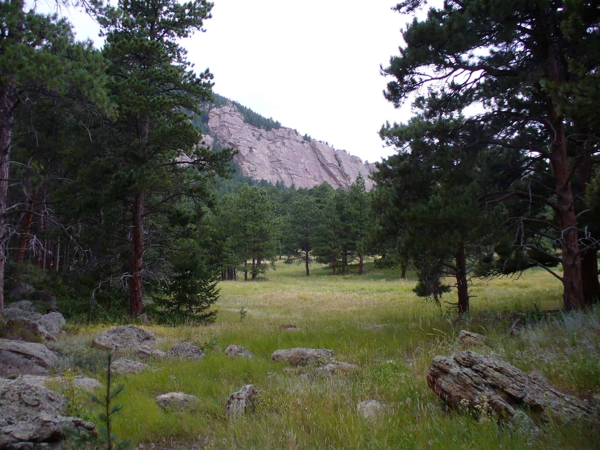
After approximately a 1/2 mile on the Mesa trail, it will intersect with the North Fork Shanahan Trail. Taking a right onto the North Fork Shanahan leads backdownhill for about 1.3 miles to the trailhead.

Tips & Resources for Hiking the Shanahan Ridge Loop
- TIP: Check ahead for trail closures.
- More Hikes in the Flatirons: Royal Arch Trail, First and Second Flatirons Hike, and Enchanted Mesa Hike.
- Trail Map: Shanahan Ridge Loop Trail
- Packing List: Always pack the 10 Essentials. Download our Hiking Guide to get the list and dayhiking packing checklist.
- Colorado Road Conditions: Colorado Road Conditions
- Photo: We would like to express our gratitude to Dave Dugdale and John Giez for sharing their photographs of this hike.
- After the Hike: The Parkway Cafe
Weather
Map & Driving Directions
Click for Driving Directions

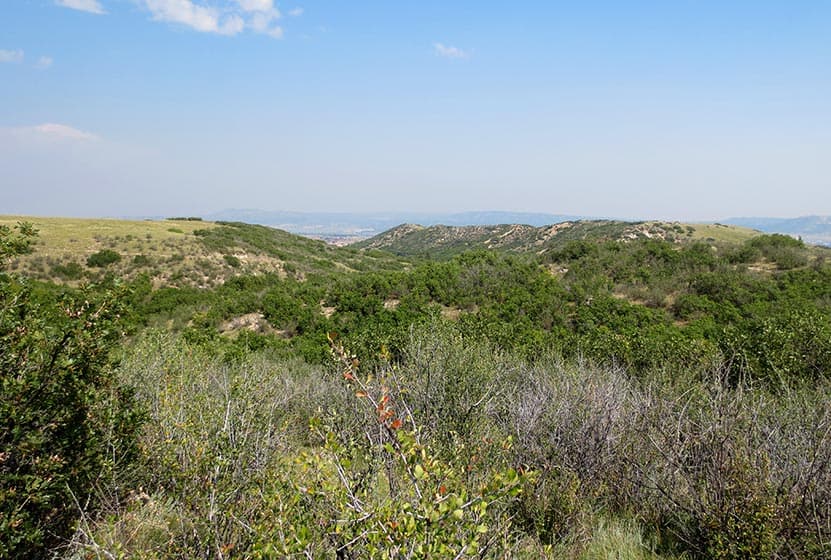
Ridgeline Open Space Hike
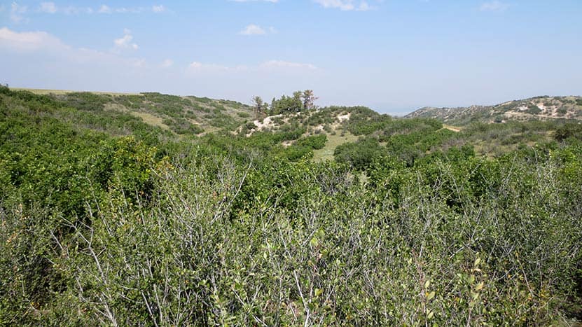
Ridgeline Open Space is nestled in the Meadows residential area of Castle Rock. This network of over 13 miles of trails winds through elevated grasslands and gamble oak with a backdrop of distant snow-capped peaks of the Front Range. Hike it or bike it for a quick escape from the work week. Explore the full Ridgeline Open Space hike profile below for trail map, driving directions, and more tips and details to help you enjoy this adventure in Castle Rock.
Trail Snapshot: Ridgeline Open Space Trail near Castle Rock, Colorado
| Hike Distance | 1 to 13.4 miles |
|---|---|
| Difficulty | Easy |
| Duration | Approx 1hr+ |
| Trail Type | Multiple Loops and Out and Back Options |
| Starting Elevation | 6600′ |
| Elevation Gain | Approx +200′ |
| Seasons | Year Round |
| Dogs | Allowed On Leash |
| Hike Trail Map | Click for a Map of Ridgeling Open Space Trails |
| Denver Drive Time | 40 min |
| Driving Directions to Meyer Homestead Trailhead | Click for Google Map |
| Town Nearest Hike | Castle Rock, Colorado |
| Beauty | grasslands, small stands of pine trees, mountain views, wildflowers, wildlife: rattlesnake, western bluebirds |
| Activities | Hiking, mountain biking, trail running |
Parking & Trailhead Information for Ridgeline Open Space
From Denver, follow Interstate 25 south to Castle Rock and take Exit 182 and go west on Wolfensberger Road. Turn right onto Coachline and follow this until to Ridgeline Open Space Trailhead (on the left-side of the road). There is a restroom and map at the trailhead. Alternatively, hikers can park at Bison Park in Castle Rock and access one of the several neighborhood access trails that lead into Ridgeline Open Space.
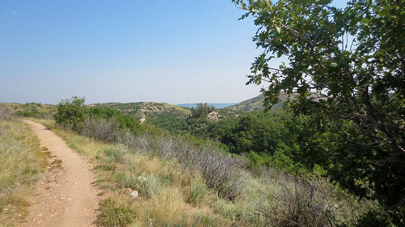
The Hike: Ridgeline Open Space
Ridgeline Open Space is one of our family's favorite places to hike because it's right in our backyard here in Castle Rock. The residents of Castle Rock also use the 13.4 miles of trail for trail running and mountain biking. It's quite a labyrinth of trails, but because it's located right in the heart of a residential area, it's hard to get lost (if you stay on the trail). There are maps posted at several junctions and trailheads along the network in the case you need to reorient yourself. Or print the map from the link above and bring it with you.
Our approach is usually to go up to Ridgeline for an afternoon and see where the trails take us. You'll likely encounter mountain bikers along the trail. Most are locals and are very considerate of hikers. Less considerate are the rattlesnakes. I've yet to run into one, but my neighbor was stopped short by a rattler recently while trail running. Rattlesnakes are only aggressive when threatened, but they are easy to stumble upon because they are so well camouflaged. So, keep your eyes peeled as you hike. Mountain Lions also frequent the area--like most trails along the Front Range--because of the plentiful deer population. It's wise to always keep your kids near when hiking and not running up the trail ahead on their own. This is just good practice on any trail, but I mention it because we have seen Mountain Lion prints in the mud on one of the western trail segments.
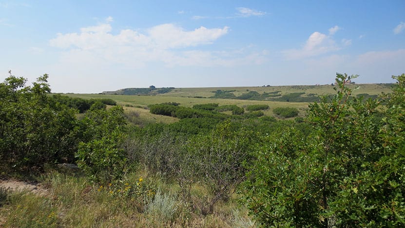
Ridgeline is aptly named because it is situated above the town and offers great views out to Longs Peak, Indian Peaks, Mt. Evans, Devil's Head to the west, and Pikes Peak to the south. Deer bed down in the grass between the gamble oak and birds flit from tree to tree along the trails.

Tips & Resources for Hiking the Ridgeline Open Space Trail
- Rattlesnakes: Keep an eye out for rattlesnakes that sun themselves on rock and the packed, warm surface of the trail.
- Hiking with Kids: As always, hike as a group, keeping small children near you. Mountain lions live in the area (as with most front-range hikes), and the sight of a small creature running alone on the trail can signal a lion's prey response.
- Sunscreen: This hike is 100% exposed to the sun's rays, so be sure to wear a hat and apply that sunscreen.
- More Hikes in Castle Rock Colorado: Castle Rock Trail, Waterfall at Castlewood Canyon, East Plum Creek Trail.
- Trail Map for Ridgeline Open Space Trail near Castle Rock: Trail Map Link
- Packing List: Always pack the 10 Essentials. Download our Hiking Guide to get the list and dayhiking packing checklist.
- Colorado Road Conditions: Colorado Road Conditions
- After the Hike: Crave Burgers
Weather
Map & Driving Directions
Click for Driving Directions
Bear Canyon Loop Hike at NCAR
The Bear Canyon Loop Hike near Boulder, Colorado is a beautiful trail that spans wide open spaces and meadows near National Center for Atmospheric Research. The Bear Canyon Loop is a relatively easy 3.3-mile loop that features some of the best views of the Flatirons in Boulder. Explore the full NCAR Bear Canyon Loop hike profile below for trail map, driving directions, and more tips and details to help you enjoy this adventure near Boulder.
Trail Snapshot: Bear Canyon Loop Trail in Boulder
| Hike Distance | Approx 3.5 Miles |
|---|---|
| Difficulty | Easy |
| Duration | Approx. 2 hrs |
| Trail Type | Loop |
| Starting Elevation | 6080′ |
| Elevation Gain | Approx +400+′ |
| Seasons | Year Round with Winter Closures |
| For Closure Updates: | Boulder Open Space Closures |
| Dogs | Allowed On Leash |
| Hike Trail Map: | Click for a Map of Bear Canyon Loop |
| Denver Drive Time | 40 Min |
| Driving Directions to NCAR Trailhead | Click for Google Map |
| Town Nearest Hike | Boulder, Colorado |
| Beauty | Canyon, Creek, Wildflowers, Meadows, Wildlife: Mule deer |
| Activities | Hiking, Photography, Birding, Running |
Parking & Trailhead: Bear Canyon Loop Trail
The National Center for Atmospheric Research (NCAR) Trailhead is located about 40 minutes North of Denver. From Denver, follow U.S. Route 36 to Boulder. Take the exit for Table Mesa Drive and follow it West. It will wind through a neighborhood to the end as it winds through the neighborhood and past Bear Creek Elementary School. The road will turn into the Drive for NCAR which winds up and around to a large parking area at the lab.
The Hike: NCAR Bear Canyon Loop Trail
From the NCAR Parking area, hikers can pick up the NCAR trail just West of the main entrance to the building. The trail heads West, over a small ridge, past a water tank, then to a fork in the trail. Both the left and the right fork are considered the NCAR trail and both will lead to the Table Mesa Trail--but the left fork is shorter. At approximately 0.7-mile into the hike, the NCAR Trail will intersect with the Table Mesa Trail. Straight through takes hikers up on a 0.8-mile hike up to Mallory Cave, but for this loop hike, the correct way is to go left/South onto the Table Mesa trail. This first stretch provides some incredible views of the magnificent Flatirons Formations of Boulder. This trail segment heading south goes in and out of a forest grove, then the trail comes to its second important intersection.
At the Bear Canyon Trail intersection, take a left onto the Bear Canyon Trail which follows Bear Creek as it descends East. At about 1.5 miles into the hike, you'll encounter another fork. You can cut off about 1/4 of a mile of the trail by taking the left-hand segment. But the right-hand trail provides more pleasant scenery along the creek. The trail will near a neighborhood then bend to the North. This straight 0.7-mile stretch follows along the Eastern boundary of NCAR. Eventually, it meets up with the NCAR trail, which will lead back on a 1/2 mile stretch to the parking area.
Tips & Resources for Hiking the NCAR Bear Canyon Loop
- Wildlife Aware: Like many of the trails in the Boulder area, keep alert because mountain lions and black bears frequent the area. Know what to do if you encounter a Mountain Lion or a Black Bear.
- Trail Map: NCAR Bear Canyon Loop Trail
- Packing List: Always pack the 10 Essentials. Download our Hiking Guide to get the list and dayhiking packing checklist.
- Explore More Flatirons Hikes in Boulder: First Flatiron Hike, Gregory Canyon Hike, Green Mountain, Enchanted Mesa Hike, and Royal Arch Trail.
- Colorado Road Conditions: Colorado Road Conditions
- Photo: We would like to express our gratitude to Dave Dugdale for sharing such an amazing photograph of this NCAR Bear Canyon Loop Trail with a view of the Flatirons.
- After the Hike: The Parkway Cafe
Weather
Map & Driving Directions
Click for Driving Directions
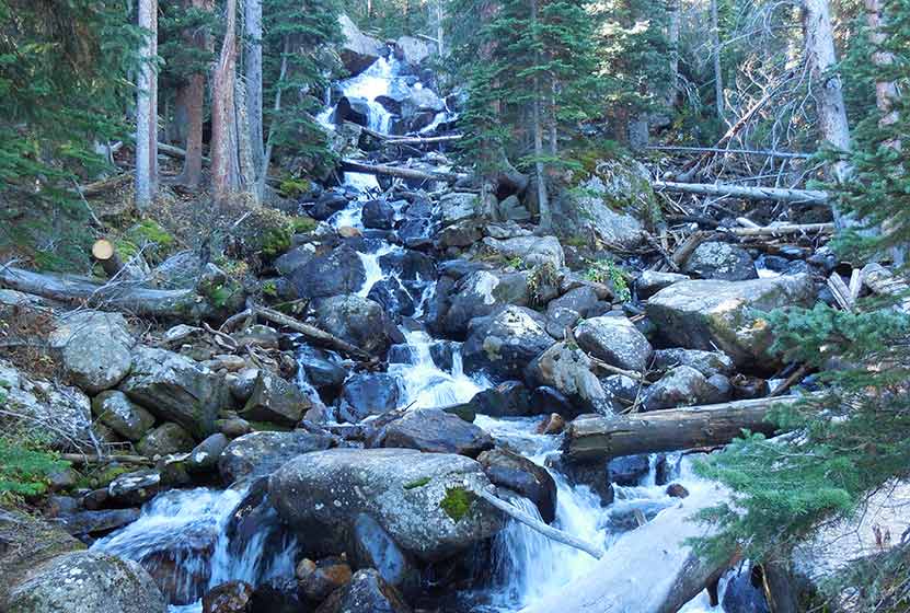
Diamond Lake Falls Hike
Diamond Lake Falls requires a 1.7 mile one-way hike into Indian Peaks Wilderness. Many hikers choose to hike the 1 mile further up to Diamond Lake. Wildflowers, cascades, and expansive mountain views are just a few of the features that make hiking to Diamond Lake Falls worthwhile. Explore the full trail profile below for trail map, driving directions, and more tips and details to help you enjoy this adventure in the Indian Peaks Wilderness.
Trail Snapshot: Diamond Lake Falls Trail
| Hike Distance | 3.4 miles Round Trip |
|---|---|
| Difficulty | Moderate |
| Duration | Approx 2.5 hrs |
| Trail Type | Out and Back |
| Starting Elevation | 10150′ |
| Elevation Gain | +800′ |
| Seasons | Late Spring through Fall |
| Dogs | Allowed On Leash |
| Hike Trail Map | Click for a Map of Diamond Lake Falls Trail near Nederland |
| Denver Drive Time | 1 hr 30 min |
| Driving Directions to 4th of July Trailhead | Click for Google Map |
| Town Nearest Hike | Nederland, Colorado |
| Beauty | waterfalls, lake, wildflowers, streams, wildlife: moose, deer, squirrel, chipmunk |
| Activities | Hiking, snowshoeing, skiing, camping, fishing |
Directions & Trailhead Information for 4th of July Trailhead
Travel for approximately for 1hr from Denver to Nederland, Colorado. From Nederland, travel south on CO 119 for about half a mile. Turn right onto CR 130 towards Eldora. Proceed westward through the town of Eldora on Eldorado Avenue which will turn into Hessie Road as it leaves town. At the intersection with CR 111 (4th of July Road) turn right and proceed to the Fourth of July Trailhead. On the way to the trailhead, you'll pass Buckingham Campground. Though this looks like a trailhead and parking area, drive past it to the actual trailhead. It is important to note that 4th of July Road is a dirt road and only useable by passenger vehicles during the Summer months, and rain and snow can cause the road conditions to be unpredictable.
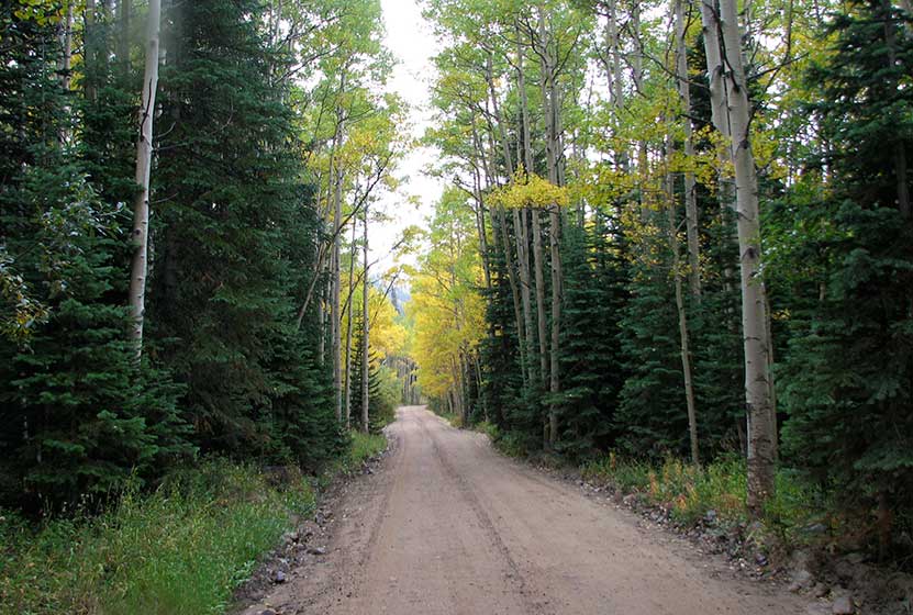
On the Way to 4th of July Trailhead
The Hike: Diamond Lake Falls Trail
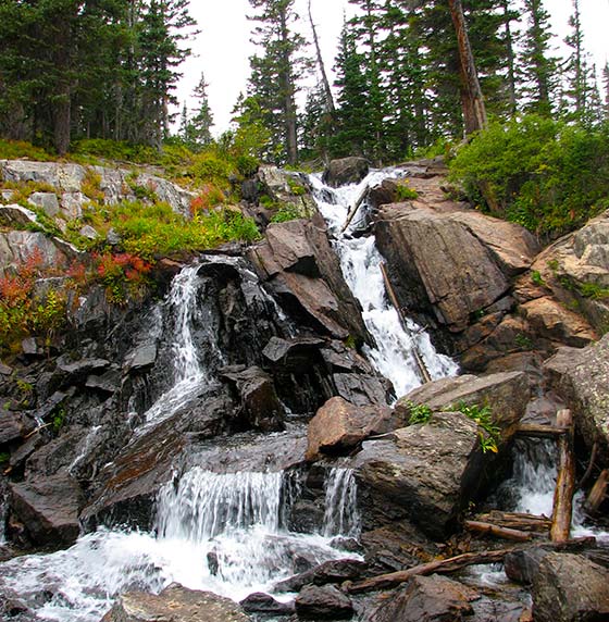
Diamond Lake Falls is actually an unnamed waterfall situated in Indian Peaks Wilderness about 1 mile below Diamond Lake where the trail crosses the North Fork of Middle Boulder Creek. Most hikers will include a stop at the falls on their way up to Diamond Lake (2.7 miles one-way). The hike begins at the 4th of July Trailhead on the Arapaho Pass Trail #904. This first segment on the Arapaho Pass trail climbs into Indian Peaks Wilderness and is adorned with wildflowers in the early and mid-Summer.
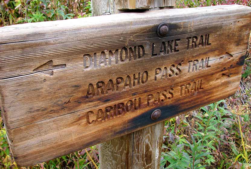
At 1.2 miles, the trail will come to a junction. The way up to Diamond Lake Falls and Diamond Lake will follow the left-hand trail. The Diamond Lake Trail first heads west along a drainage then descends to Middle Boulder Creek. This segment from the trail junction to the bridge and waterfall is 0.5 mile.

Tips & Resources for Hiking the Diamond Lake Falls Trail
- TIP: Go there early (especially during the weekends) to avoid an overcrowded parking area.
- TIP: Bring bug spray for mosquitoes.
- Trail Map: Diamond Lake Falls Trail
- Packing List: Always pack the 10 Essentials. Download our Hiking Guide to get the list and dayhiking packing checklist.
- Colorado Road Conditions: Colorado Road Conditions
- Photo: We would like to express our gratitude to Brandon Bombaci for sharing such an amazing photograph of this hike on Diamond Lake Falls.
- After the Hike: Happy Trails Cafe
Weather
Map & Driving Directions
Click for Driving Directions

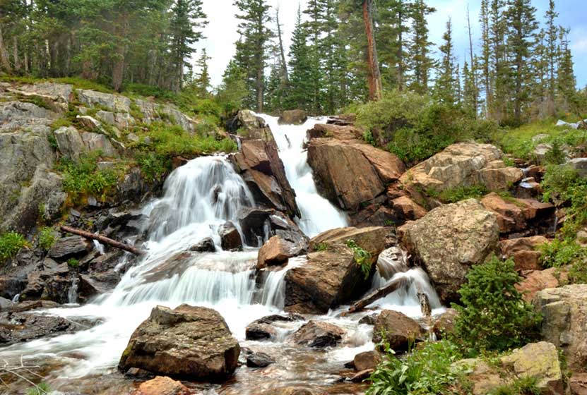
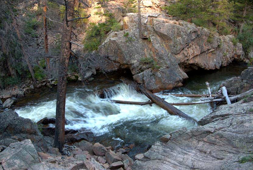
Calypso Cascades in Rocky Mountain National Park
Calypso Cascades is an easy 3.6 mile hike to one of several waterfall destinations along this section of trail. This waterfall in the Wild Basin of Rocky Mountain National Park is gets its name from the purple Calypso Orchids that bloom along the banks of Cony Creek. Explore the full Calypso Cascades hike profile below for trail map, driving directions, and more tips and details to help you enjoy this adventure in Rocky Mountain National Park.
Note: Rocky Mountain National Park now requires timed entry permits from May 27th through October 10th. See the RMNP permits page for more information.
Trail Snapshot: Calypso Cascades in Rocky Mountain National Park
| Hike Distance | 3.6 miles Round Trip |
|---|---|
| Difficulty | Easy |
| Duration | 2-3 hr Round Trip |
| Trail Type | Out and Back |
| Starting Elevation | 8566' |
| Elevation Gain | Approx. +700' |
| Seasons | Spring through Fall, Winter Snowshoeing |
| Dogs | Prohibited in RMNP |
| Hike Trail Map | Click for a Map of Calypso Cascades RMNP |
| Denver Drive Time | 1 hr 30 min |
| Driving Directions to Wild Basin Trailhead | Click for Google Map |
| Driving Directions to Winter Recreation Parking for Wild Basin Hikes | Click for Google Map |
| Town Nearest Hike | Allenspark, Colorado |
| Beauty | Waterfall, mountain views, meadows, river, wildlife: Abert's squirrel, elk, deer, moose, bear; wildflowers |
| Activities | Picnicking, hiking trails, snowshoeing, horseback riding, backcountry camping (with a permit), photography |
| Fee | Park Pass Required |
Parking & Trailhead Information for Calypso Cascades
The southeast corner of Rocky Mountain National Park boasts one of the loveliest portions in the park known as the Wild Basin. The Wild Basin Trailhead is located just 15 minutes outside of Allenspark, Colorado along Highway 115. There is a ranger station at at the Wild Basin Trailhead with toilets and drinking water available.
In the winter (October-May), Hwy 115 may not be plowed to the trailhead, and hikers will need to park their vehicles at a winter parking lot for Wild Basin hikes. Be aware that hikes from the winter parking lot add on another 3 miles of hiking (one-way). There are other small parking areas, like the Finch Lake Trailhead, that may be accessible and allow hikers to park closer to the Wild Basin Trailhead. It's important to know that Hwy 115, though titled a "highway", is a maintained dirt road, which means that it can be used by 2WD vehicles. However, after heavy rains and other severe weather, its quality may degrade until it is repaired. 4WD may be needed when snow is on the ground.
Calypso Cascades From Below
The Hike: Calypso Cascades Trail in RMNP
The hike to Calypso Cascades begins at the Wild Basin Trailhead, and at just .3 mile into the trail, passes by both the lower and upper leaps of Copeland Falls. Read our full trail profile on Copeland Falls for details on how to access both sets of cascades.
After taking in the views at Copeland Falls, the trail follows the course of North St. Vrain Creek as it flows out of the rugged high country and snowfields in this wild corner of Rocky Mountain National Park. Soon the trail will split. The right-hand trail leads through a segment of trail with 5 different backcountry camping sites and on towards Thunder and Lion lakes. These backcountry camping sites can be reserved through the RMNP Backcountry Offices. The left-hand trail leads south towards Calypso Cascades and Finch Lake Trail system.
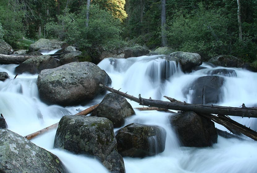
Taking the Finch Lake Trail, hikers will cross a large log bridge spanning North St. Vrain Creek. Near the bridge, you'll discover an unnamed set of cascades. After crossing the bridge, the trail follows Cony Creek for about 0.4 mile to the site of Calypso Cascades. Calypso Cascades are reminiscent of Fern Falls: the waters of Cony Creek tumble over boulders and fallen trees in a moss-covered landscape. What makes Calypso Cascades unique are the Calypso Orchids (also known as Pink Lady Slippers) that bloom in the late-spring and early-summer along the creek.
Hikers can return to the trailhead to make this a 3.6 mile hike, or can continue on the Finch Lake trail for approximately 1 mile to the site of Ouzel Falls.
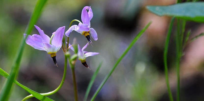
Pink Fairy Slipper Flower

Tips & Resources for Hiking to Calypso Cascades in RMNP
- TIP: The area near the bridge over North St. Vrain Creek can be a great spot for a picnic.
- Packing List: Always pack the 10 Essentials. Download our Hiking Guide to get list and dayhiking packing checklist.
- TIP: There are food storage lockers available at the Wild Basin, Finch Lake, and Sandbeach Lake Trailheads. These are required for visitors staying overnight.
- Get there early: Parking lot might get full even early in the morning.
- You're in Bear Country: Black Bears live in the Wild Basin area and are active on the months of April through November. Be aware, dispose of your food responsibly, and don't food or anything else with a strong scent in your vehicle.
- Trail Map for Wild Basin Area: Trail Map Link
- Colorado Road Conditions: Colorado Road Conditions
- Photo: We would like to express our gratitude to Jeff Kramer for sharing such an amazing photograph of this hike to Calypso Cascades in RMNP.
- After the Hike: Meadow Mountain Cafe
Weather
Map & Driving Directions
Click for Driving Directions
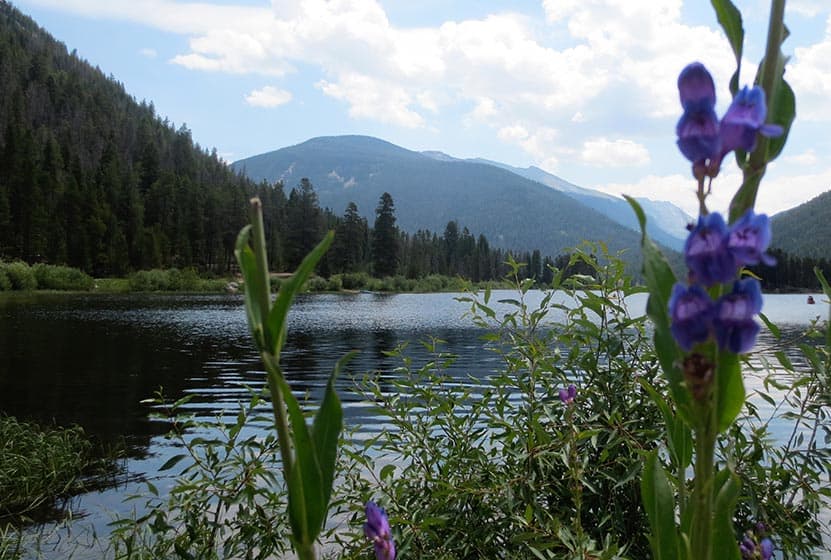
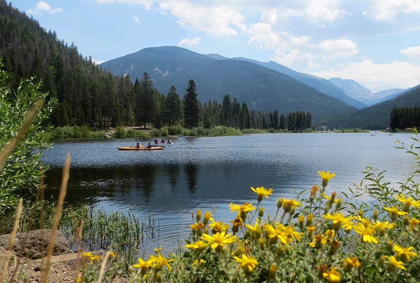
Monarch Lake Loop Hike
The Monarch Lake Loop is a perfect family hike that leads 4 miles through shaded forest, across creeks, and along the shore of the lake. It's one of the more diverse, but easy, hikes in the area. Monarch Lake is a popular destination for canoeing, kayaking, and access to the Indian Peaks Wilderness area. Explore the full Monarch Lake Loop hike profile below for trail map, driving directions, and many of the details you need to enjoy this adventure in Grand County, Colorado.
Trail Snapshot: Monarch Lake Loop, Colorado
| Hike Distance | 4 miles |
|---|---|
| Difficulty | Easy |
| Duration | Approx 2-3hr |
| Trail Type | Loop |
| Starting Elevation | 8400′ |
| Elevation Gain | Approx +300′ |
| Seasons | All Year, Road open from June 16 to Nov. 14 |
| Dogs | Allowed On Leash |
| Hike Trail Map | Click for a Map of Monarch Lake Loop |
| Denver Drive Time | 2 hr 50 min |
| Driving Directions to Monarch Lake, CO | Click for Google Map |
| Town Nearest Hike | Granby, Colorado |
| Beauty | Lake, shaded forest, wetlands, wildlife: moose, elk, deer, fox, waterfowl |
| Activities | Hiking, canoeing, horseback riding, photography, fishing |
| Fee Required | ANRA Day Use Fee |
Parking & Trailhead Information for Monarch Lake, Colorado
Following the driving directions in the above trail snapshot for Monarch Lake, the road will end at the Monarch Lake Trailhead. Here, you'll find parking spaces for about 40 vehicles. The parking area fills fast and cars and trucks often line both sides of the road to the trailhead. An Arapahoe National Recreation Area day use pass is required and can be purchased at the kiosk at the Arapahoe Bay Pay Station. This pay station is located shortly after you turn onto County Hwy 6 and before crossing over the dam. While Monarch lake is open in the winter, and Hwy 6 is plowed, the approximately 1 mile final segment of road that leads into the trailhead is closed from Nov. 15 to June 15. Because of this, hikers will have to park and snowshoe, cross-country ski, or hike in to the trailhead.
The Hike: Monarch Lake, CO
From the trailhead, a shaded tunnel of trees leads down a short gravel path to the Wilderness Information Cabin. Here you can pick up trail maps and information about hikes up into the Indian Peaks Wilderness area. The trail description here is of hiking the Monarch Lake Loop in a clockwise fashion. Begin on the Cascade Creek trail #N1. This will follow the shoreline of the lake and soon enter the forested area along the Northern end of the lake. After approximately 1 mile, the landscape changes and enters a wetland marsh. Keep your eyes peeled for moose and other wildlife here.
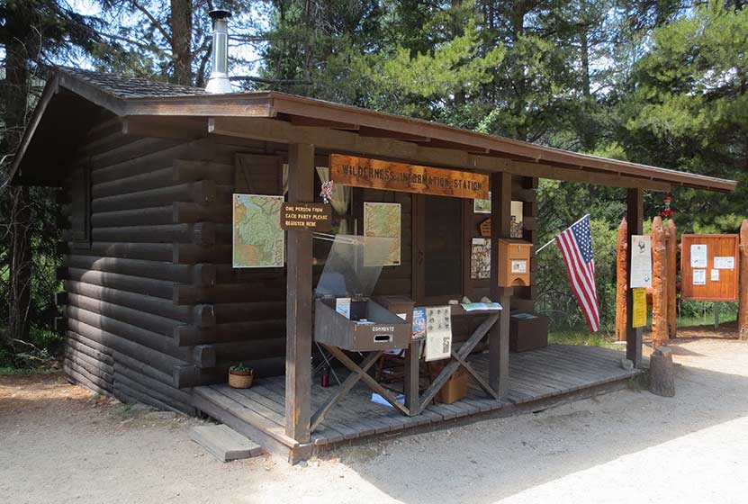
Wilderness Info Cabin at Monarch Lake
After 1.5 miles on the Cascade Creek Trail, the loop will be continued by taking a right onto the Arapaho Pass Spur Trail. This will head south, crossing Buchanan Creek, then Arapaho Creek. Here, after .8 mile, the spur trail ends and the Arapaho Pass trail begins. This last segment on the Arapaho Pass trail #N6 is 1.7 miles long.
Because of the pine beetle kill, there are many dead trees throughout the Monarch Lake Loop hike. Be alert for falling trees, especially when gusts of wind blow through. Hikers may also encounter deadfall across the trail. Be careful going under any fallen trees as they are often unstable and may only be supported by a few small, dead branches.
The hike continues on the south shore of the lake, passing an old, rusty steam engine. These "steam donkeys" were used to pull logs down out of the mountains back in the logging camps of the 1800's. After the steam engine, the trail will cross two more creeks, and finally make its way across the dam at the northwestern end of the Lake.
Because this hike is so perfect as a family outing, or for visiting family and friends, we recommend the following day trip:
1) Leave early (take breakfast with you) and arrive at the trailhead at or before 8AM (better chance of seeing wildlife and better parking)
2) Hike Monarch Lake
3) Drive over Trail Ridge Road (fee required--but worth every penny)
4) Eat a late Lunch in Estes Park (so bring snacks)
5) Head back home or drive in to Moraine Park in Rocky Mountain National Park.
Tips & Resources for Hiking the Monarch Lake Loop
- Fishing: Monarch Lake is a popular fishing spot for trout. Colorado State fishing regulations apply.
- Falling Trees: Because of the amount of dead trees in this area, hikers should be on alert for falling trees.
- Trail Map for Monarch Lake Area: Trail Map Link
- Packing List: Always pack the 10 Essentials. Download our Hiking Guide to get list and dayhiking packing checklist.
- Colorado Road Conditions: Colorado Road Conditions
- After the Hike: Mavericks Grill in Granby, CO
Weather
Map & Driving Directions
Click for Driving Directions
The Pool in Rocky Mountain National Park
It's a 1.7 mile hike in to The Pool, a series of turbulent cascades and deep green-blue waters formed by the confluence of the Big Thompson River and Fern Creek. This is another popular and easy hike from the Fern Lake trailhead in Rocky Mountain National Park, and a great destination along the Fern Lake Trail. Explore the full hiking trail profile below for trail map, driving directions, and more of the details you need to enjoy this adventure in Rocky Mountain National Park.
Note: Rocky Mountain National Park now requires timed entry permits from May 27th through October 10th. See the RMNP permits page for more information.
Trail Snapshot: The Pool in Rocky Mountain National Park
| Hike Distance | 3.4 miles Round Trip (from Fern Lake TH) |
|---|---|
| Difficulty | Easy |
| Duration | Approx 2 hr Round Trip |
| Trail Type | Out and Back |
| Starting Elevation | 8155' |
| Elevation Gain | Approx. +245' |
| Seasons | Spring through Fall |
| Dogs | Prohibited in RMNP |
| Hike Trail Map | Click for a Map of The Pool RMNP |
| Denver Drive Time | 1 hr 40 min |
| Driving Directions to Fern Lake Trailhead | Click for Google Map |
| Driving Directions to Fern Lake Bus Stop Parking | Click for Google Map |
| Driving Directions to Park & Ride Trailhead | Click for Google Map |
| Town Nearest Hike | Estes Park, Colorado |
| Beauty | Sub-alpine lakes, mountain views, river, wildflowers, aspen trees, ponderosa pine, wildlife: Abert's squirrel, elk, deer, moose, duck, beaver, chipmunk, bear |
| Activities | Picnicking, hiking trails, snowshoeing, fishing |
| Fee | Park Pass Required |
Parking & Trailhead Information for The Pool in RMNP
Parking is more limited in this area of Rocky Mountain National Park, and you'll likely have to park at the Park & Ride then take the shuttle to the Fern Lake Trailhead. You'll find driving directions above to The Fern Lake Trailhead (closest to this hike), the Fern Lake Bus Stop Parking area (very limited parking), and for the Park & Ride lot. See the RMNP Shuttle page for dates and times of service. Avoid parking along Fern Lake road as this damages the road side. If you park or are dropped off at the Fern Lake Bus Station, the hike from the station to the trailhead will add and additional .8 mile, one-way, to your hike.
The Hike: The Pool in RMNP
The hike to The Pool, and other destinations along this initial stretch of the Fern Creek trail--such as Arch Rocks and Windy Gulch Cascades--follows the Big Thompson River as it courses through a rocky, but verdant, valley. There are great places to stop to fish along the banks of the Big Thompson for trout.
At approx 1.5 mile, you'll encounter a huge rock, split in two segments that bridges over the trail. Arch Rock likely broke off the cliff side above and tumbled down into the valley eons ago. It's a remarkable site.
Another .7 miles further, hikers will arrive at The Pool, an unusual set of cascades formed by the confluence of Fern Creek and the Big Thompson River. Here, the waters collide and swirl, and have carved out a deep pool of chaotic--but beautiful--waters. Don't be fooled by the name, The Pool is not a place to swim. The current is powerful and dangerous; so, stay out of the water and be sure to exercise caution along the slick rock edges of the Pool.
At the Pool, there is a footbridge that crosses the river. It's a great spot to stop and take in the sights.
Tips & Resources for Hiking to The Pool in Rocky Mountain National Park
- TIP: It is advisable to arrive early as parking is limited. Hikers may opt to ride a shuttle that drops you off at the trailhead.
- Bring A Picnic Lunch: The banks along the Big Thompson River can be a great place for picnics.
- Trail Map for Bear Lake Corridor: Trail Map Link
- Packing List: Always pack the 10 Essentials. Download our Hiking Guide to get list and dayhiking packing checklist.
- Colorado Road Conditions: Colorado Road Conditions
- Photo: We would like to express our gratitude to Charlie Stein for sharing such an amazing photograph of this hike to the Pool in Rocky Mountain National Park.
- After the Hike: Baba's Burgers & Gyros
Weather
Map & Driving Directions
Click for Driving Directions
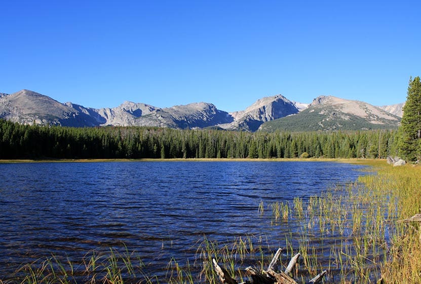
Bierstadt Lake in Rocky Mountain National Park
Bierstadt Lake is a short destination hike in Rocky Mountain National Park to a sub-alpine lake with great panoramic views. At Bierstadt Lake, the trail forms a 1 mile loop along its shores, making it a perfect leisurely hike with friends. Bierstadt lake can be accessed from several different trailheads with differing terrain and demand. Explore the full Bierstadt Lake hike profile below for trail map, driving directions, and more of the details you need to enjoy this adventure in Rocky Mountain National Park.
Note: Rocky Mountain National Park now requires timed entry permits from May 27th through October 10th. See the RMNP permits page for more information.
Trail Snapshot: Bierstadt Lake in Rocky Mountain National Park
| Hike Distance | 3.2 to 4.8 miles Round Trip (depending on trailhead and adding loop) |
|---|---|
| Difficulty | Easy to Moderate |
| Duration | Approx 2 hrs Round Trip |
| Trail Type | Out and Back or Lollipop Loop |
| Starting Elevation | 8850′ |
| Elevation Gain | +566' from Bierstadt TH, +255' from Bear Lake TH |
| Seasons | Spring through Fall, Winter Snowshoeing |
| Dogs | Dogs Prohibited in RMNP |
| Hike Trail Map | Click for a Trail Map |
| Denver Drive Time | 2 hr |
| Driving Directions to Bierstadt Lake Trailhead | Click for Google Map |
| Driving Directions to the Bear Lake Trailhead | Click for Google Map |
| Driving Directions to Park & Ride Trailhead | Click for Google Map |
| Town Nearest Hike | Estes Park, Colorado |
| Beauty | Sub-alpine lakes, mountain views, wildlife: Abert's squirrel, elk, deer, waterfowl, moose; aspen trees |
| Activities | Picnicking, Hiking Trails, Snowshoeing |
| Fee | Park Pass Required |
Parking & Trailhead Information for Bierstadt Lake Trail
Bierstadt Lake can be accessed from several trailheads in Rocky Mountain National Park. Driving directions to all of these trailheads are available in the Bierstadt Lake trail snapshot above. Review the options below to find the best fit for your hiking plans.
From the Bierstadt Trailhead: Limited parking and the most difficult route because of the elevation gain traversing Bierstadt Moraine. This route is 1.4 miles to the lake with +566' elevation gain.
From Bear Lake Trailhead: Recommended for those looking for a less demanding hike to Bierstadt Lake. This way is 1.6 miles to the lake with about +255' elevation gain.
From the Park & Ride lot in RMNP: There is a trail on the northwestern edge of the parking lot that leads directly to Bierstadt Lake. It is approximately 1.5 miles from the parking lot to Bierstadt Lake and a less demanding route than hiking from the Bierstadt Trailhead.
The Hike: Bierstadt Lake Trail in RMNP
The hike to Bierstadt Lake will be different depending on your starting point. I've hiked the trail starting at the Bierstadt Trailhead. It's demanding. The Bierstadt Moraine will require a lot from your quads. So, if you take this route, be sure to bring some trekking poles.
The route from Bear Lake can be accessed by hiking the paved path from the trailhead to Bear Lake, then taking the first right-hand trail, which is the one that leads to Flattop Mountain. You may be thinking, "Flattop is in the west, and Bierstadt Lake is in the east." You're right, and the trail will soon (after approx. 1/2 mile) split. At this first junction, the right-hand path will take you Northeast into the Mill Creek Basin area.
Down in Mill Creek Basin, a spur trail, to the right, will lead to Bierstadt Lake. If you want to make your hike a bit longer, you can pass this spur trail, and hike further through the basin for about another 1/2 mile until you encounter a 2nd spur trail that leads (to the right/east) over to Lake Bierstadt.
Hikers can pick a spot to rest and enjoy the sites of the lake, or they can continue around the 1 mile loop trail that encircles it. The best views are from the east side, and are worth the extra distance to take in some incredible views of the Rocky Mountains.
Tips & Resources for Hiking to Bierstadt Lake in RMNP
- Trekking Poles: For most hikes in RMNP, especially if you are traveling on unmaintained trails, we recommend using Trekking Poles. They take a lot of weight off the knees and help in navigating uneven terrain.
- TIP: The Bierstadt Lake trailhead has limited parking. You can opt to park at Bear Lake, or the Park & Ride trailhead instead.
- Fishing: Bierstadt Lake is not on the list of fishable lakes in RMNP.
- Trail Map for Bear Lake Corridor Trails: Trail Map Link
- Packing List: Always pack the 10 Essentials. Download our Hiking Guide to get list and dayhiking packing checklist.
- Colorado Road Conditions: Colorado Road Conditions
- Photo: We would like to express our gratitude to Chris for sharing such an amazing photograph of this hike to Bierstadt Lake in RMNP.
- After the Hike: Baba's Burgers & Gyros
Weather
Map & Driving Directions
Click for Driving Directions
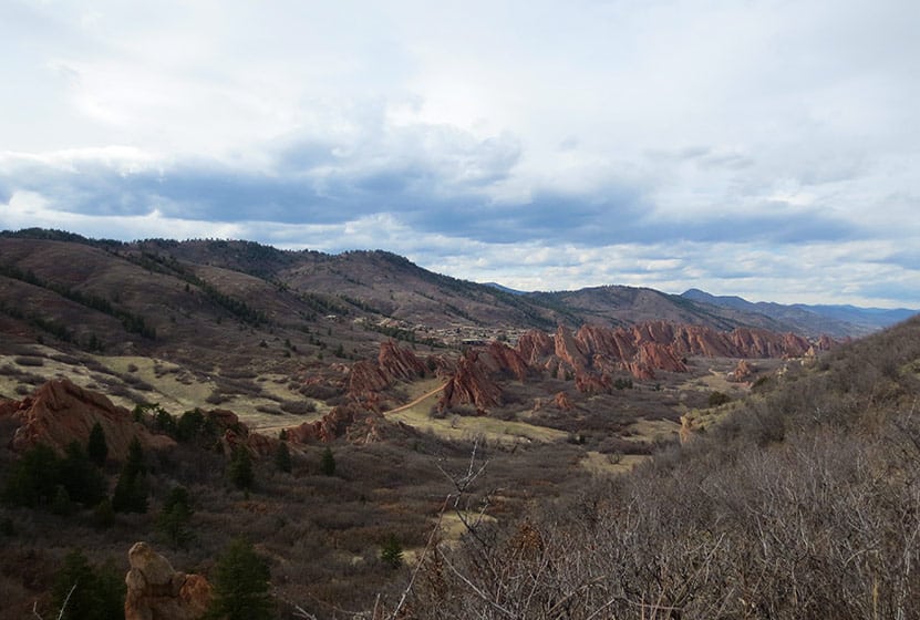
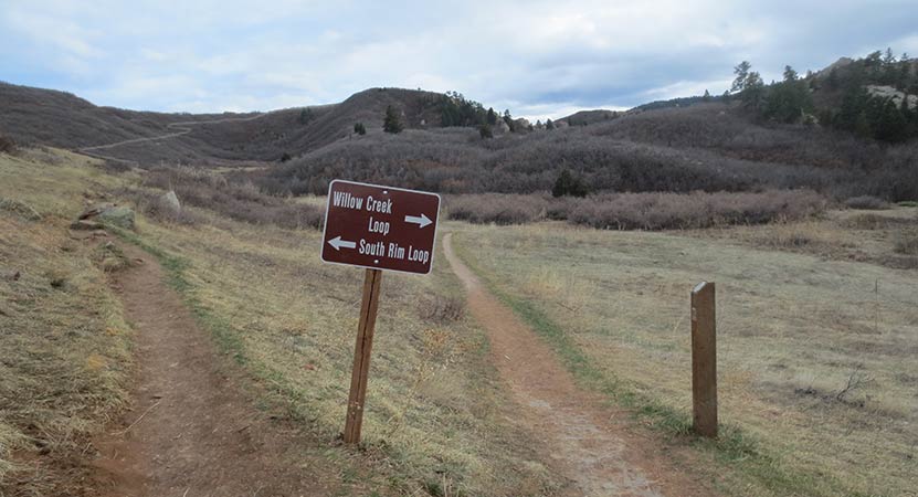
South Rim Loop Trail at Roxborough State Park
The South Rim Loop Trail at Roxborough State Park is a moderate hike that leads to breathtaking views of the red rock formations that make this Colorado State Park famous. It's a perfect hike for a weekend afternoon, or a great choice for visiting family and friends. We also put this on our list for great hikes to take if you want to acclimatize before hiking into higher altitudes deeper in the mountains. Read further to explore the trail details, tips, and to get the trail map for this adventure in Roxborough State Park.
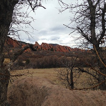
Roxborough State Park is like the Garden of the God's of Denver. Nestled against the foothills south Littleton, Colorado, it makes for a quiet escape from the sounds of the city. The South Rim Trail provides some of the best vantage points for photography of the Fountain and Morrison formations, the same rock that forms sister parks, Garden of the Gods in Colorado Springs, and Red Rocks Park in Morrison.
Trail Snapshot: South Rim Loop Trail at Roxborough State Park
| Hike Distance | 3 miles |
|---|---|
| Difficulty | Moderate |
| Duration | Approx 1.5 hr |
| Trail Type | Loop |
| Starting Elevation | 6200′ |
| Elevation Gain | Approx +250′ |
| Seasons | Year Round |
| Dogs | Prohibited in Roxborough State Park |
| Hike Trail Map | Click for a Map of Roxborough State Park |
| Denver Drive Time | 45 min |
| Driving Directions to Roxborough State Park | Click for Google Map |
| Town Nearest Hike | Littleton, Colorado |
| Beauty | Red rock formations, meadows, wildlife: mule deer, eagles, foxes, birds |
| Activities | Hiking, birdwatching, Visitors’ Center |
| Fee | Entrance Fee or State Parks Pass Required |
Parking and Trailhead Information
The last two miles of access road into Roxborough State Park are a maintained dirt road, but it can get washboarded and can be tough on the car. Still, it's not a long drive in. Undulating green hills can be seen to the west where deer and antelope graze. Roxborough can fill up during it's busiest hours on the weekend. If that's the case, you can wait until enough vehicles exit the park then drive in. My guess is that the peak times are around 10AM-2PM. If the line looks long, you can always turn around and head over to Waterton Canyon or to South Valley Park--both are great options.
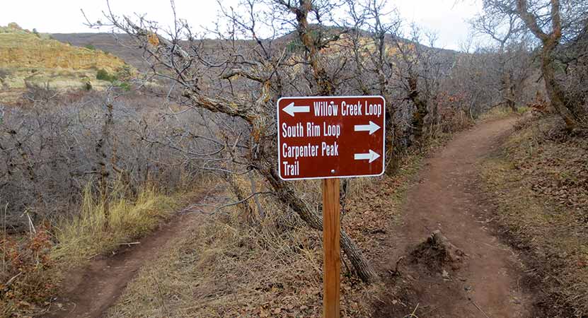
The South Rim trail begins just west of the visitor center and makes its way through tunnels of scrub oak. This first trail segment takes you to several different destinations: the Willow Creek Loop, Carpenter Peak, and Elk Valley.
The trail will eventually come to a small meadow with a lone cottonwood tree. Here the trail forks and the trail to the lef leads to the rest of the South Rim Trail. It crosses a small brook via a footbridge and into an area that our kids kept calling the "magical forest." The way the light plays in Roxborough State Park is enchanting. I think it has something to do with how the hogback formations and the red rocks filter the light coming into the valley.
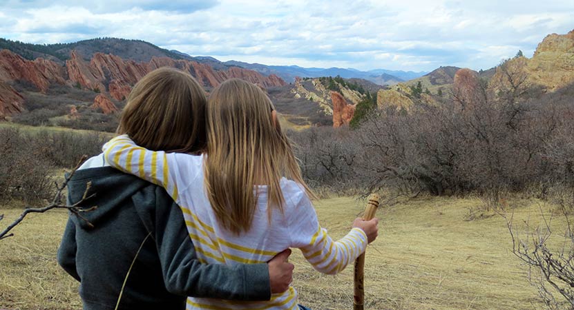
About 1 mile into the hike, the trail begins to climb. We've rated this trail as moderate because the climb may be challenging for those not acclimated to the altitude or who are not in great shape. The great news is that there are benches placed at regular intervals along the trail. A couple of these bench sites offer incredible overlooks into the park and are ideal points for photographing fountain valley. Most of the benches offer shade in bowers under fir and scrub oak trees.
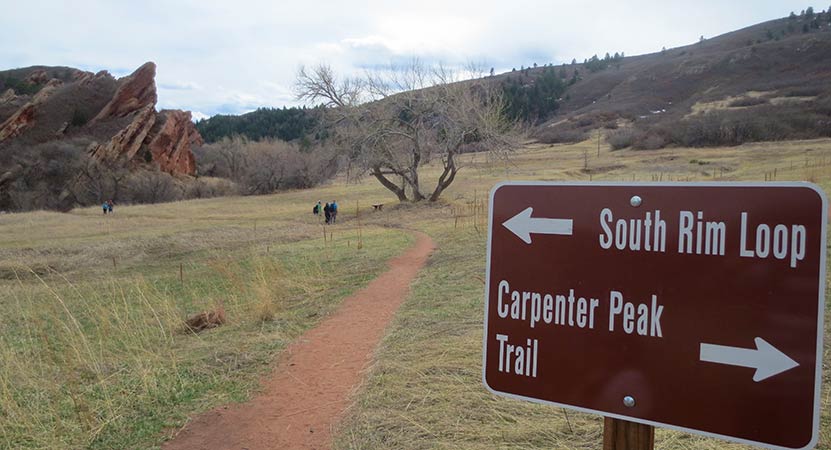
The South Rim Trail makes its way over the top of a bright and orange cliff band that dominates the southern end of the park for most of the hike. At the highest point, a very short spur trail affords hikers views to the east, and another viewpoint on the descent offers views to the north, all the way into the city of Denver.
Be mindful of the loose gravel as the trail descends back into the valley. Back on the valley floor, the trail will fork again. To the left (west) will take hikers onto the Willow Creek trail, adding approximately 1/2 mile onto the loop back to the visitor center, making it a 3.5 mile hike. Or you can continue North for approximately 1/2 mile back the the parking area.
Tips & Resources for Hiking the South Rim Loop in Roxborough
- Loop Hiking Direction: This description of the South Rim Loop is hiked as counter-clockwise. Just reverse the description for hiking the trail to hike the loop clockwise.
- Hiking in Winter: If you plan to hike the South Rim Trail in the winter, it is advised that you have traction devices like YakTrax because much of the trail will be in shadow, and ice will likely form on the trail.
- Trail Map for Roxborough State Park: Trail Map Link
- Packing List: Always pack the 10 Essentials. Download our Hiking Guide to get list and dayhiking packing checklist.
- Colorado Road Conditions: Colorado Road Conditions
- After the Hike: Waterton Tavern in Roxborough
Weather
Map & Driving Directions
Click for Driving Directions
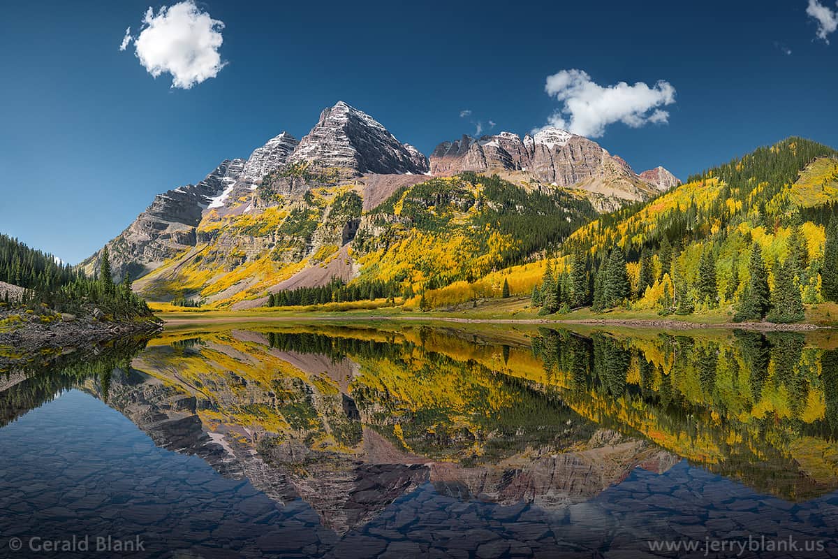
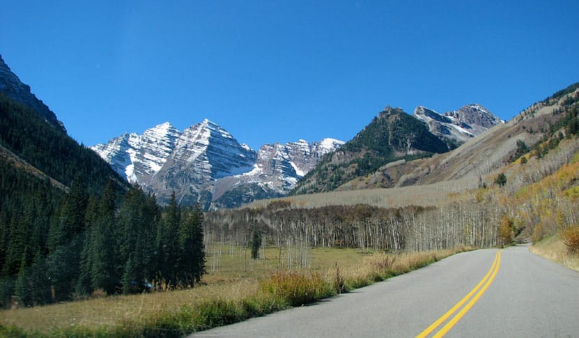
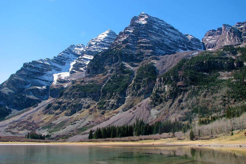
Ultimate Guide to Maroon Bells in Colorado
The Maroon Bells offer several hikes and some of the most beautiful scenery in Colorado. It's a Rocky Mountain landscape painted with cascades, lakes, golden aspens, and all against the backdrop of the peaks of the Maroon Bells. This guide to the Maroon Bells features 5 different hiking trail options, spanning from easy hikes to moderately demanding. Because traffic in this area has skyrocketed in recent years, a fee is required to access whether you are driving in or taking the shuttle.
We've attempted to create the definitive guide to hiking from the Maroon Bells Trailhead. In this guide, you'll find: Driving directions to Maroon Bells, Trail Maps, Important Shuttle Bus information, Photography tips, Camping information for the Maroon Bells area, and Tips & Resources for planning your Colorado Vacation. This guide to Maroon Bells is extensive, so we have created a table of contents to help you navigate. Have fun exploring!
Maroon Bells Hiking Guide Contents
1. Trail Snapshot
2. Driving Directions: Parking, Fees, and Permits
3. Parking & Trailhead
4. Hiking the Trail
5. Maroon Lake Trail
6. The Scenic Loop Trail
7. Maroon Creek Trail
8. The Crater Lake Trail
9. The Willow Lake Trail
10. Photography
11. Hiking with Kids
12. For Out-of-State Hikers
13. Things to Do Nearby
14. History and Geology
15. Protect Maroon Bells
Maroon Bells Hike Snapshot
Hike DistanceFive Trails: 1 to 13 miles Round Trip - Depending on TrailDifficultyEasy to ModerateDurationDepends on Hike (see trails below)Trail TypeBoth Loop and Out-and-Back HikesStarting Elevation9500′Elevation GainNominal up to +3030'SeasonsMid-May to Mid-November (weather dependent)DogsAllowed On 6' leash - but Prohibited on the Scenic Loop TrailHike Trail MapClick for a Map of Maroon Bells Area HikesDenver Drive Time4 hoursDirections Click for Driving Directions to Maroon Bells Town Nearest HikeAspen, ColoradoBeautyIconic Mountain Views, Lakes, Meadows, Tundra, Fall Aspens, Moose, Beaver, and ElkActivitiesHiking, Backpacking, CampingFeeAccess Fee of $10 per vehicle or individual shuttle bus fee
Driving Directions to Maroon Bells: Parking, Fees, and Permits
Because the Maroon Bells trailhead is one of the heaviest used recreation areas in the state of Colorado, there are some driving and access restrictions during the busy summer months. That's why it's important to carefully read these details before you plan your trip.
The Basics
- The Maroon Bells Trailhead is seasonal, and closed from about mid-November though mid-May. Because snow is unpredictable, the exact dates may change. Check the AspenChamber.org page for the most up-to-date and accurate information.
- Parking is very limited at the Trailhead and requires both a permit/reservation and fee. Read all the details at the AspenChamber.org Maroon Bells Reservations page.
- During the busy season, you have to arrive and park at the trailhead by 8AM or After 5PM.
- Most visitors will need to take the shuttle in during the day. Tickets are available online at the RFTA website https://www.rfta.com/routes/maroon-bells/
- Be prepared to shell out some cash for the trip. Parking in Aspen is both limited and expensive. Parking + shuttle costs can really add up for a group. The least expensive way to visit, is to book a parking permit for the trailhead (often many weeks ahead of time) at https://aspenchamber.org/plan-trip/trip-highlights/maroon-bells/reservations
- Plan, Plan, Plan: There are still a ton of places in Colorado where you can jump in the car, drive to a trailhead, and hike. Maroon Bells is not one of them. So, take your time, make your reservations, and plan out your trip.
Driving Directions
There are three different sets of driving directions that you may find helpful.
- Driving Directions to the Maroon Bells Trailhead
- Driving Directions to the Maroon Bells Shuttle Bus service at Aspen Highlands
- Driving Directions to the Rubey Park in Aspen for the free shuttle to Aspen Highlands where you can catch the Shuttle
Access Tips for Maroon Bells in the Summer
- If the Aspen Highlands lot is full--which is often the case--, you can take the free Castle/Maroon bus from Rubey Park in Aspen to Aspen Highlands, where can pick up the Maroon Bells shuttle (link and map for directions to Rubey Park).
- It's also important to note that if your plans are to backpack and camp in the Maroon-Snowmass Wilderness, you will not be given a parking exception, but will need to take the bus in from the Aspen Highlands lot during the 8am-5pm timeframe.
- Another option is to cycle the 8 miles, one-way from Aspen Highlands up to the Maroon-Snowmass trailhead. There is no fee for cyclists, only vehicles. However, it's important to remember that the road is still very busy, even during the 8am-5pm hours when the driving restrictions apply. As with hiking the area, plan to bring proper gear for the frequent afternoon thunderstorms--yet another reason to go early.
- Driving Out: It's important to note that if you drive in to the trailhead, you may drive out at any time.
Access Tips for Maroon Bells During the Rest of the Year
- In Late-Spring: From when Maroon Creek road opens, which is historically mid-May, and until mid-June--when the shuttle bus service starts--you are allowed to drive the road from 8am-5pm. Of course, permits are still required.
- In Late-Fall: There is a small window, during the last week of October, when you can drive Maroon Creek road to the trailhead any day and any time of the week. Again, the access fee applies. See details at https://aspenchamber.org/plan-trip/trip-highlights/maroon-bells/reservations
- Maroon Bells During the Winter Months: Winter comes in early at this elevation and it holds on well through April. Maroon Creek road is closed during the winter months, beginning in mid-November. Until the road reopens around mid-May of each year, the trailhead is only accessible by hiking in, cross-country skis, or via snowmobile tours. Snowmobile tours can be booked through T-Lazy-7 Ranch. From the gate, the hike/ski in is about 6 miles one-way, and from Aspen Highlands, it's about 8 miles one-way.
Parking and Facilities at the Maroon Bells Trailhead
The Maroon Bells Trailhead--officially titled the Maroon-Snowmass Trailhead--has limited parking and no facilities, except for restrooms. There is plenty of space to lock up your bike on the provided bike racks. There are 35 parking spaces designated for backpackers who are overnighting in the wilderness and you may park for up to 5 consecutive nights in those designated spots. These fill up during the busy season, so be sure to have the shuttle as your plan-b. If you get to Aspen Highlands after the last bus, then you will need to have a plan-c: take a taxi (expensive) in or ask a friend to drive you into the trailhead. Overnight backpackers are not allowed to park in the day-use area. Again, get all the details and permits at https://aspenchamber.org/plan-trip/trip-highlights/maroon-bells/reservations
Guide for Hiking at Maroon Bells
Trail Option #1 - The Maroon Lake Trail at Maroon Bells
- Distance: Less than One Mile
- Difficulty: Easy
- Trail Type: Out & Back
- Elevation Gain: Nominal
The Maroon Lake Trail heads out from the trailhead to the northeast side of Maroon Lake (elevation 9580’) where hikers can take in iconic views of the peaks of the Maroon Bells reflected in its mirrored waters. Fishing is allowed at Maroon Lake, but a Colorado fishing license is required. Be sure to follow limits and regulations. Bring a picnic lunch and soak in the scenery, which includes aspen groves, Maroon Creek, and surrounding meadows. Do be mindful to stay to the trail as the high amount of foot traffic has a profound impact on the environment. For tips on taking a great photo of the Maroon Bells, check out the Photography at Maroon Bells section below.
Trail Option #2 - The Scenic Loop Trail at Maroon Bells
- Distance: 3 Miles
- Difficulty: Easy
- Trail Type: Lollipop Loop
- Elevation Gain: Approx. +120'
- Dogs are prohibited because of Moose inhabiting this area.
The Scenic Loop Trail is probably the most popular trail at Maroon Bells, and for good reason: the views are incredible, the loop takes you along the cascades of Maroon creek for much of the hike, and wildflowers spring up at your feet along the trail. A lollipop loop is a hike that begins with a straightaway (part of the out & back hike above), which takes you to a loop on the end. The Scenic Trail Loop begins at a footbridge on the far/west end of the lake. A way up the trail, hikers will notice another footbridge on the right. This can be taken to shorten the trip by crossing the creek then turning right to head back to Maroon Lake and the trailhead. However, the loop trail actually goes further and past some exceptionally beautiful cascades before turning back toward Maroon lake.
Trail Option #3 - The Maroon Creek Trail
- Distance: 2.5 or 3.5 Miles - One-Way
- Difficulty: Easy
- Trail Type: One-Way
- Elevation Gain: -870'
- Maroon Creek Lake Trail Map: Map Link
If you are looking for a less crowded option, the Maroon Creek Trail may be the best choice. The Maroon Creek Trail winds downhill alongside Maroon Creek for 3.5 miles. Being near water, the chances of seeing wildlife are pretty good. Maroon Creek Trail begins at Maroon Lake and the trail can be picked up by hiking across the footbridge, turning left, then following the trail down into the valley (away from the Maroon Bells). The trail offers two options.
#1 - 2.5 Mile Hike:
Hikers will encounter and cross a bridge at about 2.5 miles into their hike. At this point, a trail off to the left can be taken across the meadow and up to the road where they can catch the bus back to Aspen Highlands or back to the trailhead. Of course, be mindful of the traffic.
#1 - 3.5 Mile Hike:
The second option is to continue on the trail, cross another bridge, then to stay left onto the East Maroon Trail. This will wind downhill a bit further to another area where you can catch the bus along Maroon Creek Road. As you hike, don't forget to stop occasionally to take in the views behind you of the Maroon Bells.
Trail Option #4 - The Crater Lake Trail at Maroon Bells
- Distance: 3.6 Miles Round Trip
- Difficulty: Moderate
- Trail Type: Out & Back
- Elevation Gain: +500'
- Crater Lake Trail Map: Map Link
The Maroon/Snowmass trail (right of lake) will lead hikers through a meadow and to a forest service bulletin board at the far end of the lake. From this point the correct trail is the West Maroon/Crater Lake trail which leads up through meadows, aspens forests, and scree fields. The trail can be extremely rock, so be sure that you have excellent footwear. The trail will split at about 1.7 miles where the correct trail to follow is the West Maroon/Crater Lake Trail. At this point, Crater Lake is not far away. The trail will eventually dip down into a beautiful basin that holds Crater lake and incredible views of the Maroon Bells. Crater Lake is not stocked or fishable as it is a dead lake. It is also an area that has been negatively impacted by heavy use and poor camping practices. Because of this, camping is now prohibited and great care should be exercised to keep human and canine impact to a minimum.
Trail Option #5 - The Willow Lake Trail at Maroon Bells
- Distance: approx. 13 Miles Round Trip
- Difficulty: Difficult
- Trail Type: Out & Back
- Elevation Gain: +3020' to Willow Pass
- Willow Lake Trail Map: Map Link
The Willow Lake trail is demanding and may require an overnight. The trail begins at Maroon Lake and follows the same trails that lead to Crater Lake. At the Crater Lake bulletin board, the trail forks to right and makes its way up through Minnehaha gulch, through alpine meadows and eventually to a trail sign for Maroon-Snowmass/Willow Lake Junction. Here the trail goes to right. Switchbacks lead to top of Willow Pass. After making it over Willow Pass, Willow Lake is a more gradual 1.5 miles further down the trail. This hike is difficult, steep, and more exposed to the regular thunderstorms that form in the afternoons. Camping is prohibited in the meadow near Buckskin Pass, and camping is discouraged at Willow lake. The best option is to camp in the established sites in Minnehaha Gulch.
Get our Dayhikes Near Denver Hiking Guide. It includes our favorite hikes near Denver, packing lists, hiking food and snack ideas, and tips for hiking the Front Range of Colorado.
Photography: How to Get Great Photos of the Maroon Bells
We would like to thank photographer Jerry Blank for the stunning photo of the Maroon Bells at the top of this post. We asked him for a few photography tips and he emphasized the importance of arriving early in order to 1) get a parking spot, and 2) to get a shot of the water before the wind kicks up ripples on the early morning mirror surface of the lakes. More of his photos can be viewed and prints can be ordered from his galleries at this link.
- Fall is the Best Time for Photos: The changing aspens peak in their golden hues during the latter half of September. However, this is just a rule of thumb because much depends on the changing temperature, so it varies from year to year.
- Sunrise Shots are Primo: We all have our best side, and the Maroon Bells' best side faces east. This means that the morning sunrise provides the best opportunity for photos.
- What Time Should I Get There? Earlier than you think. The shoreline of Maroon Lake fills up fast with tripods, so you'll want to get there well before sunrise.
- Dress for the Occasion: Wear your down coat and bring a thermos of hot coffee. The morning breeze and cold temps will conspire to make the wait for sunrise a cold one.
Hiking with Kids at Maroon Bells
- Hydrate: We hike a lot with our kids and it's easy for them to get dehydrated, especially in the dry climate and at high altitude in Colorado. Bring water bottles full of water for everyone.
- Pack Snacks or Bring a Lunch: The drive back to Maroon Bells takes you pretty far out of town and you'll want to stay a while. Bring snacks or a picnic lunch to refuel while you are exploring.
- Choose a Hike with Options: If your children are younger then you may want to begin with the Maroon Lake Trail. If you are still feeling adventurous after that, you could add on all or part of the Scenic Loop. Be aware of Moose and keep your distance from them.
Visiting Maroon Bells From Out-of-State
- Download our Hiking Guide for a list of hiking tips, 10 essentials that everyone should pack for their dayhike, and recommended hiking snacks.
- Take it Easy: Hiking at altitude (almost 2 miles above sea level at the Maroon Bells trailhead) can be really demanding. Choose a trail that matches your physical shape and be prepared to go at a slower pace.
- Don't Drink from Streams or Lakes: There is a misconception that drinking from a mountain stream or lake is the purest water in the world--it's not! Mountain streams and lakes are watering holes for wildlife, especially rodents that carry parasites like giardia and other waterborne infectious diseases that can completely ruin your vacation. All water from these areas should be properly filtered and/or purified.
Camping Near Maroon Bells
There are three established USFS camping areas along Maroon Creek Road on your way in to the Maroon Bells Trailhead. These three are some of the more popular campsites in the state during the summer and fall, so you will want to reserve them well ahead of time. You'll find profiles for the three camping areas below. Reservations can be made at all three campgrounds by calling 1-877-444-6777 or by reserving online at www.recreation.gov
Crater Lake Campground has been closed because of bear activity in the past, so be sure to check to see if it is currently open. However, there are about 20 USFS campgrounds in the White River National Forest area near Aspen. The USFS has a handy camping brochure that can be downloaded at this link.
Silver Bar Campsite
- Driving Directions to Silver Bar Campground: Click for Directions
- Four primitive walk-in campsites only
- Elevation: 8500'
- Drinkable water and toilets, as well as picnic tables and fire-grates are available.
- Five-day camping limit with 2pm checkout.
- Eight-person, two car limit per campsite.
- Pets allowed but must be leashed at all times.
- Reservable Dates: 5/26 - 9/13
- Fees: Camping Fee + Vehicle Fee
Silver Bell Campsite
- Driving Directions to Silver Bell Campground: Click for Directions
- Fourteen campsites
- Elevation: 8350'
- Drinkable water and toilets, as well as picnic tables and firegrates are available.
- Five-day camping limit with 2pm checkout
- Eight-person, two-car limit per campsite.
- Pets allowed but must be leashed at all times
- 30' RV limit
- Reservable Dates: 5/26 - 9/13
- Fees: Camping Fee + Vehicle Fee
Silver Queen Campsite
- Driving Directions to Silver Queen Campground: Click for Directions
- Six campsites
- Elevation: 9100'
- Drinkable water and toilets, as well as picnic tables and firegrates are available.
- Five-day camping limit with 2pm checkout
- Eight-person, two-car limit per campsite.
- Pets allowed but must be leashed at all times
- 30' RV limit
- Reservable Dates: 5/26 - 9/13
- Fees: Camping Fee + Vehicle Fee
Backcountry Camping in the Maroon Bells/Snowmass Wilderness
- Camping is allowed within the Maroon Bells/Snowmass Wilderness area. Be sure to follow all the Wilderness Use Regulations and Practice Leave No Trace principles.
- Camping at the designated spots at Crater Lake is currently allowed, but has been closed in 2014-2015 because of increased bear activity in the area, which is due to poor camping practices. The USFS will close the area again if bear activity becomes problematic.
- Bear canisters are required
- Self-registration required at the trailhead
- Pets allowed but must be on a 6' leash at all times in the wilderness.
Things to Do Near Maroon Bells
- White Water Rafting with Aspen Whitewater Rafting
- Guided Climbing, Hiking, and Mountaineering Trips with Aspen Alpine Guides
- Winter Snowmobile Access to Maroon Bells with T-Lazy-7 Snowmobile Tours
History and Geology of Colorado’s Maroon Bells
The brick red color of the Maroon Bells is created by the oxidation of iron in the ancient sedimentary rock that makes up the mountains. They were formed when ancient granite mountains eroded, then were thrust toward the sky in a later mountain building event. Glaciers then cut valleys and cirque lakes, like Maroon Lake and Crater Lake. The Maroon Bells are considered Colorado Fourteeners with North Maroon at 14,014' and the summit of South Maroon Peak at 14,156'. They are called "the bells" because the shape of the mountains resemble church bells. The surrounding Maroon Bells-Snowmass Wilderness area was one of the first US Wilderness areas established in 1964. The ruins of mine riddle the landscape from the silver mining activity of the late 1800's.
The sedimentary siltstone that makes up the Maroon Bells and nearby mountains, like Pyramid Peak, makes them very dangerous to climb. It's described by climbers as "rotten" rock and very unstable. In fact, in 1965 there were five different climbing accidents on the Maroon Bells, taking the lives of eight climbers. This gave the Maroon Bells the new monicker, the "Deadly Bells". There are yearly accidents and usually deaths on the Bells. Because of this, we recommend that those contemplating an ascent of the Maroon Bells should contact a professional guiding service.
How You Can Protect the Maroon Bells Area
- Camp in Designated Spots: Camping has been prohibited at many of the high-mountain lakes in the Maroon Bells-Snowmass area in order to protect these overused and highly impacted environs. The USFS has inventoried over 700 campsites, that have impacted the equivalent of 35 football fields of land. So, be sure to use established camping areas in both the wilderness and along Maroon Creek road.
- Keep Out of the Water: People and Dogs can greatly disturb fragile ecosystems in streams and lakes because of detergents and oils on our clothing and skin. The water sources around Maroon Bells are at a much higher risk because of the sheer volume of hiker and backpacker traffic.
- Keep Dogs on a 6' Leash: I have regularly hiked with my dog for years, and have often let her off the leash. But in the last few years, I've become much more aware that man's best friend has a significant impact on the wildlife that make our wilderness areas their home. Even in areas that don't require leashes, I now leash our dog. As much as you would love for your dog to run free, it's important to remember that both we and our dogs are guests in this place and we want to leave the least amount of impact possible. Of course, this is a 6' leash required area. The Ranger District is now giving special attention to unleashed dogs and writing tickets.
- Pack Out All Trash: It should probably go without saying, but be sure to pack out your trash, including both human and dog waste. In 2015 alone, forest rangers packed out over 500 pounds of trash left by visitors to the Maroon Bells-Snowmass area.